
 Traveler Tips
Pocket Fire Update: Sedona Is Open — What Visitors Should Know
By Rupa Chenthil · Published July 18, 2026 · 6 min read
Last updated: July 18, 2026. The Pocket Fire is burning in the Red Rock–Secret Mountain Wilderness northwest of Oak Creek Canyon, several miles north of Sedona. Here's the latest official update, what it means for your visit — and the short version up front: Sedona is open for business, SR 89A through Oak Creek Canyon has reopened, and the current thing to watch is monsoon flash-flood risk over the burn scar, not the fire itself.
The latest official update
As of Tuesday, July 14, fire officials report the Pocket Fire holding at 27,393 acres with containment now at 83% — the footprint itself is essentially unchanged; the jump in containment reflects crews locking down the last stretches of line, including the previously inaccessible heat pocket above the West Fork of Oak Creek, which is now well secured after earlier retardant drops and recent rain. Command of the incident has passed from California Interagency Incident Management Team 6 to a local U.S. Forest Service Type 3 team, and Tuesday's report was described as the incident's last full formal update — a sign the fire has moved from active firefighting into mop-up, suppression-repair, and monitoring. Remaining crews are focused on repair work (chipping in the Enchantment area and along the 535 Road is expected to wrap up within a couple of days) as resources continue to demobilize. Officials had previously estimated full containment around July 31; with the fire now largely locked down that could arrive sooner, though official updates may become less frequent from here — check the sources below for the latest. As of this update, 83% / 27,393 acres remains the last officially reported containment figure; no newer percentage has been issued. Attention has now shifted from firefighting to recovery: a U.S. Forest Service Burned Area Emergency Response (BAER) team has begun surveying the burn scar for post-fire hazards — erosion, flooding, and impacts to trails and roads — as the area heads into monsoon season.
Evacuation status is unchanged since Monday's downgrades: all areas previously under "SET" (be-ready-to-leave) status remain at "READY." The Coconino County Sheriff's Office downgrade of Oak Creek Canyon and the Yavapai County Sheriff's Office downgrade of the Seven Canyons/Enchantment area and adjacent canyon-corridor zones are still in effect, alongside Kachina Village, Forest Highlands, and Pinedale, which had been downgraded to "READY" earlier still. No community remains under a "SET" or "GO" order, and the city of Sedona itself is not under any evacuation notice. SR 89A through the canyon remains open to all traffic. Evacuation status can change quickly as conditions evolve — for the full, current list of zones and their status, check the Arizona Emergency Information Network and Yavapai/Coconino County alerts.
Sedona is open — here's what that looks like
Uptown, West Sedona, Tlaquepaque, the Chapel area, and the Village of Oak Creek are all open and operating normally — restaurants, galleries, tours, and trailheads on the south and east sides included. Both main visitor approaches are open: SR 179 from I-17 and SR 89A from Cottonwood. As of Monday, SR 89A through Oak Creek Canyon to Flagstaff has also reopened to all traffic after nearly a month of restricted access — expect continued fire-response traffic and the possibility of intermittent delays in the canyon. Favorites on the south and east sides — Cathedral Rock, Bell Rock, and Airport Mesa — are open and unaffected. Note that trailheads on the northwest side, including the Soldier Pass area (the access route to Seven Sacred Pools), remain inside the active fire closure — see the list below and always confirm on the official sources before you set out.
Smoke is no longer the main concern day-to-day — it tends to settle into Sedona and the Verde Valley overnight and in the early morning on the rare days it's still noticeable, then lifts and clears by midday as winds shift. The extreme heat warning that covered the area through July 12 has expired, but Sedona summer temperatures still run hot — hydrate well, avoid outdoor exertion during peak afternoon hours, and never leave kids or pets in a parked car.
The current weather item to plan around is monsoon-season flash flooding over the Pocket Fire burn scar. With ground cover burned away, afternoon storms run off bare, steep slopes fast instead of soaking in, and the National Weather Service has been issuing flash flood watches and warnings covering Oak Creek Canyon, the West Fork of Oak Creek, Slide Rock State Park, and at times parts of Sedona itself. If you're driving SR 89A through the canyon or hiking near washes, dry creek beds, or low-water crossings when storms are in the area, get to higher ground and wait it out — flash flooding in a burned canyon can happen with little warning. Check the National Weather Service Flagstaff office for current watches and warnings before heading into the canyon or backcountry.
What's closed right now
Closures on an active fire change faster than any blog can keep up with, so treat the list below as orientation and confirm the exact, current closures on the official sources before you go. The good news: SR 89A through Oak Creek Canyon reopened to all traffic Monday, July 13. The remaining closures under the Coconino National Forest closure order are concentrated in the forest northwest of town and inside the Oak Creek Canyon burn area:
- Slide Rock State Park plus the Oak Creek Canyon campgrounds, picnic areas, and day-use sites (Cave Springs, Pine Flat, Bootlegger, Manzanita, Call of the Canyon/West Fork, Oak Creek Vista, Grasshopper Point, Midgley Bridge, and others).
- A number of northwest-side trailheads — Soldier Pass (the access for Seven Sacred Pools), Jim Thompson, Fay Canyon, Bear Mountain, Loy Canyon, Secret Canyon, Sugarloaf, Thunder Mountain, and more — plus Dry Creek Road access points.
- Some interior forest roads, including a stretch of Woody Mountain Road south of Forest Road 536.
For the authoritative, up-to-the-day list, check the Coconino National Forest closure order, AZ511 for roads, and Visit Sedona's Pocket Fire page. Trails on the south and east sides — Cathedral Rock, Bell Rock, Airport Mesa — remain open.
What this means for Sedona Haven guests
Our West Sedona homes are outside all evacuation and closure areas and are hosting guests normally. Our Top of the World home sits in the Oak Creek Canyon area, which was downgraded from "SET" to "READY" on July 13 as SR 89A reopened — if you have an upcoming stay there, access should be back to normal, though expect occasional fire-response traffic in the canyon. If you have any questions about your stay, contact us and we'll work with you on options.
We're locals, we're watching this closely, and we'll keep this post updated as containment grows. Sedona's red rocks aren't going anywhere — and neither are we. Come visit.
Pocket Fire FAQs
Is Sedona open during the Pocket Fire?
Yes. The city of Sedona is under no evacuation notice. Uptown, West Sedona, Tlaquepaque, the Chapel area, and the Village of Oak Creek are open and operating normally, along with most trails on the south and east sides of town.
Is it safe to visit Sedona right now?
The fire is burning in remote wilderness several miles north of town and containment is growing along the edges closest to populated areas. The main day-to-day effect in town is haze that settles in overnight and typically clears by midday — smoke-sensitive visitors should plan indoor mornings and outdoor afternoons.
Which trails and roads are closed because of the fire?
SR 89A through Oak Creek Canyon reopened to all traffic on July 13. Remaining closures are Slide Rock State Park, the canyon campgrounds, and several trailheads on the northwest side of town (Soldier Pass, Thunder Mountain, Fay Canyon, Bear Mountain, and others). Cathedral Rock, Bell Rock, Airport Mesa, and most other favorites are open. Check AZ511 for current road conditions.
Can I stay in Oak Creek Canyon right now?
Yes — as of July 13, SR 89A through the canyon has reopened to all traffic and Oak Creek Canyon, along with the Seven Canyons/Enchantment area, has been downgraded from "SET" to "READY." Expect occasional fire-response traffic and possible intermittent delays as crews finish mop-up work. As always, check ein.az.gov for the current status before you go.
Will the fire affect my Sedona Haven reservation?
Our West Sedona homes are outside all evacuation and closure areas and hosting guests normally. Our Top of the World home in the Oak Creek Canyon area was downgraded from "SET" to "READY" on July 13 as SR 89A reopened, so access should be back to normal. If you have any questions about your stay, contact us and we'll work with you on options.
For official information: visitsedona.com/pocket-fire · Arizona Emergency Information Network · AZ511 road conditions
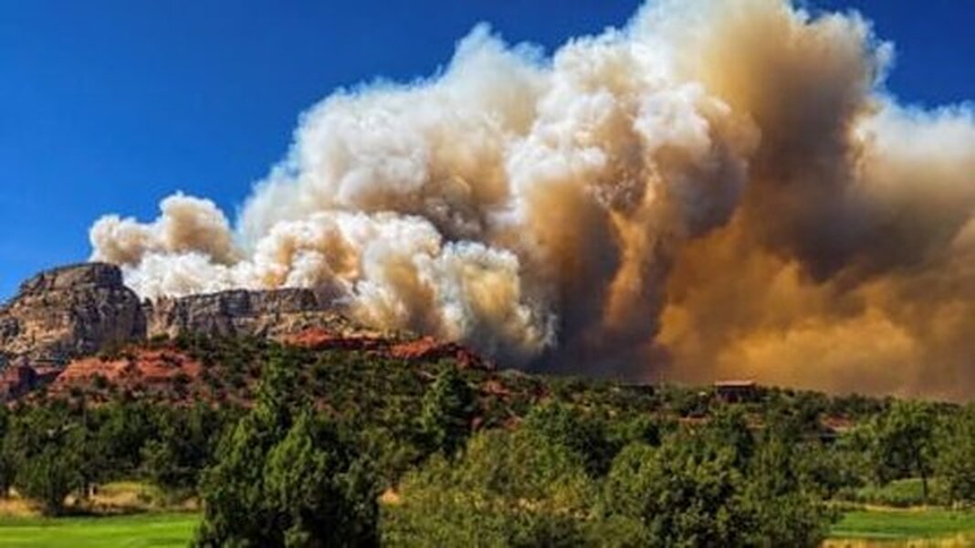
Photo: the Pocket Fire smoke column, July 1, 2026 — courtesy Coconino National Forest / U.S. Forest Service (public domain).
Where to stay in Sedona
Make a weekend of it — base your trip at one of our luxury Sedona vacation rentals, each with a private hot tub, red-rock views, and room to unwind after the trail.



More in Traveler Tips
Plan your Sedona stay
Browse our hand-picked vacation rentals — book direct and save vs Airbnb / Vrbo.
View Properties